The United States of America, a vast country spanning across the continent of North America, borders Canada to the north and Mexico to the south. You can touch the surface of the country’s diverse landscapes, iconic landmarks, and rich history on a United States map. Whether you are a geography aficionado, a student, or simply someone curious about the U.S., a detailed map of the United States can serve as a window to understanding the country’s geography, politics, culture, and history.
Interactive United States Map
The Geography of the United States
The U.S. is characterized by its varied geographical features – from the summits of the Appalachian Mountains to the expansive deserts of the Southwest, the peaks of the Rocky Mountains to the sprawling Great Plains and the scenic coastal regions along the Atlantic and Pacific Oceans. Our United States map shows its 50 states and major cities, but also highlights important topographical features and terrain.
The United States is known for iconic features such as the steaming geysers of Yellowstone National Park in Wyoming, the rolling sand dunes of Death Valley in California, the subtropical flora of the Everglades marshlands in Florida, and the awe-inspiring spectacle of the Redwood forests along the West Coast. Familiarizing yourself with a map of the U.S. puts into perspective the massive scope of the country. A glance can take you on a grand tour from East to West, showcasing more than just political subdivisions.
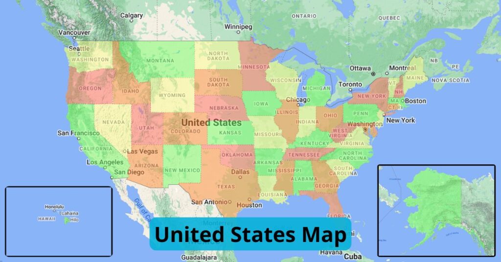
Based on a mathematical theorem, you need only four colors in a map so that adjacent regions are different colors. Below is a version of a United States map showcasing this theorem, as it only uses four colors: light yellow, orange, red, and green.
Historical Landmarks and Tourist Attractions
A map of the United States may not showcase the historical landmarks that tell the story of the nation. For example, icons like the Statue of Liberty, the Golden Gate Bridge, and the Lincoln Memorial. Attractions that draw visitors from around the globe dot the U.S., whether it’s the bustling streets of New York City, the exciting glimmer of Hollywood in Los Angeles, or the serene beaches of New Jersey, North Carolina, and Hawaii.
State Capitals
These are all of the capital cities across each of the 50 states in the U.S.
| State | Capital | State | Capital |
| Alabama | Montgomery | Montana | Helena |
| Alaska | Juneau | Nebraska | Lincoln |
| Arizona | Phoenix | Nevada | Carson City |
| Arkansas | Little Rock | New Hampshire | Concord |
| California | Sacramento | New Jersey | Trenton |
| Colorado | Denver | New Mexico | Santa Fe |
| Connecticut | Hartford | New York | Albany |
| Delaware | Dover | North Carolina | Raleigh |
| Florida | Tallahassee | North Dakota | Bismarck |
| Georgia | Atlanta | Ohio | Columbus |
| Hawaii | Honolulu | Oklahoma | Oklahoma City |
| Idaho | Boise | Oregon | Salem |
| Illinois | Springfield | Pennsylvania | Harrisburg |
| Indiana | Indianapolis | Rhode Island | Providence |
| Iowa | Des Moines | South Carolina | Columbia |
| Kansas | Topeka | South Dakota | Pierre |
| Kentucky | Frankfort | Tennessee | Nashville |
| Louisiana | Baton Rouge | Texas | Austin |
| Maine | Augusta | Utah | Salt Lake City |
| Maryland | Annapolis | Vermont | Montpelier |
| Massachusetts | Boston | Virginia | Richmond |
| Michigan | Lansing | Washington | Olympia |
| Minnesota | Saint Paul | West Virginia | Charleston |
| Mississippi | Jackson | Wisconsin | Madison |
| Missouri | Jefferson City | Wyoming | Cheyenne |
Create Your Own States Map
You can make your own United States map using ZeeMaps by following these steps.
- Create a New Map on ZeeMaps.
- In Additions, choose “Upload (Copy/Paste) Spreadsheet” and add your data to the map. Use this guide to learn how to add colors to your map. You can choose up to 75 different colors to design your map on ZeeMaps.
- Select United States as the starting position.
- Choose “US States” as the upload type.
- You can add terrain features to your map. On the map view, click “Map” (next to “Satellite”) and check the box for terrain.