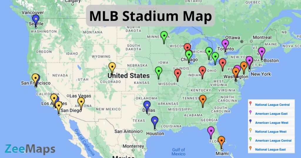
Looking for baseball fields near you? This interactive MLB stadium map marks each of the fields in major league baseball in the United States (and one in Canada).
The map is encoded using color to denote which league each team plays in. The breakdown of the leagues can be found below. In the map, cool-toned colors represent members of the American League (blue, green, and purple), while warm-toned shades denote members of the National League (yellow, red, and orange).
Interactive MLB Stadium Map
MLB Stadiums
American League Stadiums
| Stadium | Team | Region |
| Angel Stadium | Los Angeles Angels | West |
| Comerica Park | Detroit Tigers | Central |
| Fenway Park | Boston Red Sox | East |
| Globe Life Field | Texas Rangers | West |
| Guaranteed Rate Field | Chicago White Sox | Central |
| Kauffman Stadium | Kansas City Royals | Central |
| Minute Maid Park | Houston Astros | West |
| Oakland-Alameda County Coliseum | Oakland Athletics | West |
| Oriole Park at Camden Yards | Baltimore Orioles | East |
| Progressive Field | Cleveland Guardians | Central |
| Rogers Centre | Toronto Blue Jays | East |
| T-Mobile Park | Seattle Mariners | West |
| Target Field | Minnesota Twins | Central |
| Tropicana Field | Tampa Bay Rays | East |
| Yankee Stadium | New York Yankees | East |
National League Stadiums
| Stadium | Team | Region |
| American Family Field | Milwaukee Brewers | Central |
| Busch Stadium | St. Louis Cardinals | Central |
| Chase Field | Arizona Diamondbacks | West |
| Citi Field | New York Mets | East |
| Citizens Bank Park | Philadelphia Phillies | East |
| Coors Field | Colorado Rockies | West |
| Dodger Stadium | Los Angeles Dodgers | West |
| Great American Ball Park | Cincinnati Reds | Central |
| LoanDepot Park | Miami Marlins | East |
| Nationals Park | Washington Nationals | East |
| Oracle Park | San Francisco Giants | West |
| Petco Park | San Diego Padres | West |
| PNC Park | Pittsburgh Pirates | West |
| Truist Park | Atlanta Braves | East |
| Wrigley Field | Chicago Cubs | Central |
Static MLB Stadium Map
Create Your Own Baseball Stadium Map
You can make your own interactive MLB stadium map using ZeeMaps by following these steps.
- Create a New Map.
- In Additions, choose “Upload (Copy/Paste) Spreadsheet” and add your data to the map.
- Select United States as the starting position.
- Choose “Pinned Circles” as the upload type.
To make your map static instead of interactive, save it as a PNG or PDF. Simply use the Print or Share option, then click “PDF/PNG Image.” You can play around with the settings to get the image to look the way you want it to. With options like satellite image vs. map image, different pin aesthetics, image resolution, and size, there are various ways to customize your map using ZeeMaps.