
With over a hundred colleges with football teams in the NCAA across the United States, one of the best ways to visualize them all is on a college football map. We created an interactive map that showcases where all of the college football teams in the U.S. are housed, color coded by the conference each team is in.
Are you a football fan? Don’t miss our interactive NFL map and our Super Bowl LIX map, which showcases who America is rooting for.
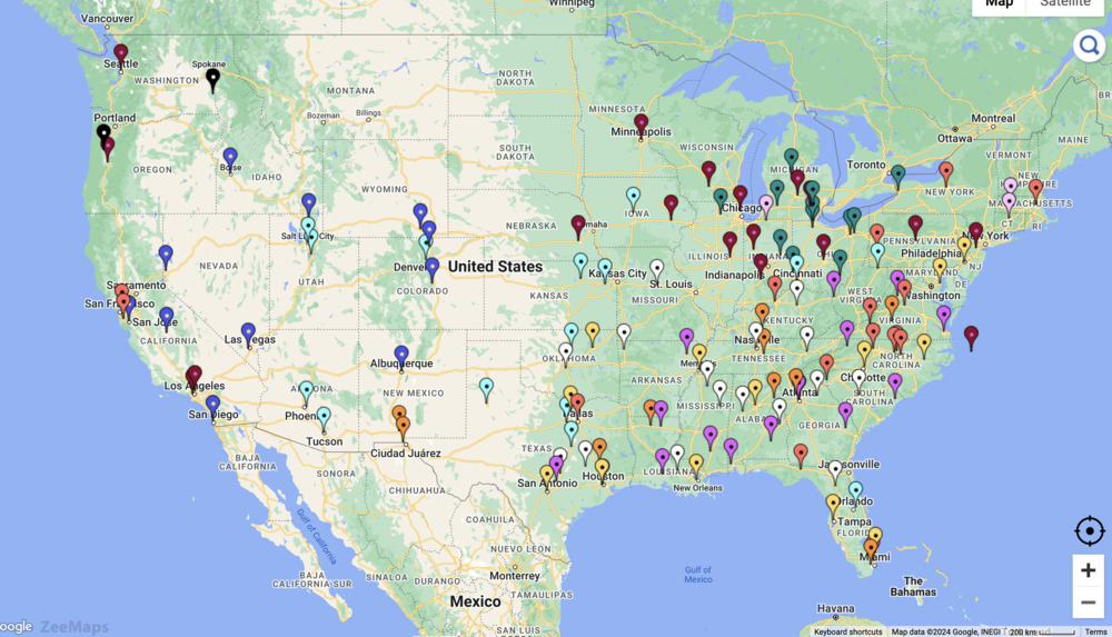
Interactive College Football Team and Stadium Map
This map shows all 134 of the colleges in the Division I Football Bowl Subdivision (FBS) of the National Collegiate Athletic Association (NCAA) in the United States. In the map, we used color coding to designate the conference each school is in. Below is a list of the conferences and color-coding scheme the map uses.
| Conference | Color |
| Atlantic Coast Conference (ACC) | red |
| Conference USA (CUSA) | orange |
| American Athletic Conference (AAC) | yellow |
| Big Ten Conference (B1G) | burgundy |
| Mountain West Conference (MW) | blue |
| Sun Belt Conference (SBC) | purple |
| Big 12 Conference | light blue |
| Mid-Atlantic Conference (MAC) | teal |
| Southeastern Conference (SEC) | white |
| Pacific 12 Conference (Pac-12) | black |
| Independent | light purple |
Static College Football Team Map
Create Your Own College Football Map
You can make your own interactive college football and team map using ZeeMaps by following these steps.
- Create a New Map.
- In Additions, choose “Upload (Copy/Paste) Spreadsheet” and add your data to the map.
- Select United States as the starting position.
- Choose “Pinned Circles” as the upload type.
- To add labels to your map, go into the “Settings” page. Click on the “Markers Display” tab, and check the box for “Label Markers using.” Select the field value that will supply the labels for the pins.
To make your sports map static instead of interactive, save it as a PNG or PDF. Simply use the Print or Share option, then click “PDF/PNG Image.” You can play around with the settings to get the image to look the way you want it to. With options like satellite image vs. map image, different pin aesthetics, image resolution, and size, there are various ways to customize your map using ZeeMaps.